English Street Donnybrook Precinct Structure Plan (Amendment C183)
The English Street Donnybrook Precinct Structure Plan (PSP) sets out the planned development of a residential and commercial area, supporting services and infrastructure. The area is expected to provide 1,200 new homes and 700 new jobs.
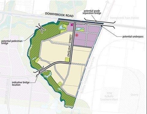
About the precinct structure plan
The area covers approximately 143 hectares of land, bound to the north by Donnybrook Road, to the east by the Melbourne-Sydney railway line, and by Merri Creek to the south and west.
The plan promotes areas of diverse mixed use commercial and residential areas located within walking distance of the existing Donnybrook Railway Station.
What the plan includes
Proposed community infrastructure and services include:
- a community centre
- a local convenience centre including day-to-day small retail space
- commercial/employment areas
- sport facility
- local parks, and connections to the Merri Creek trail.
Planning Scheme Amendment C183
The English Street Donnybrook PSP was approved as part of Whittlesea Planning Scheme Amendment C183 following the recommendations in the Panel report.
The Amendment rezoned the land to Urban Growth Zone Schedule 4 as well as updating the Planning Overlays which affect the land.
For more information relating to Amendment C183, visit the VPA website.
Read about the plan
For more information on the English Street Precinct Structure Plan and the amendment, visit the Victorian Planning Authority page.